

Adventure Riding Trail Maps
Elk Valley routes
Areas worth exploring in the Elk Valley. Scenic routes, local loops, Trail Maps.
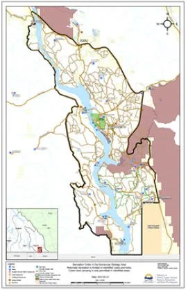
Exploring the Greater Koocanusa Recreation area
This is for Adventure/Dual-Sport riding purpose.
For single-tracks/dirt biking, see our Koocanosa Trail Map page.
Important Links.
Forest Service Road Use Regulation: https://www.bclaws.gov.bc.ca/civix/document/id/complete/statreg/70_2004
Frequencies for BC Resource Roads Channels:Click Here.
Koocanusa Recreation website:https://www.koocanusarecreation.ca/
Disclaimer.
Copyright EVADRS.CA 2026. All tracks distributed as a guide only - the user takes full responsibility for any use they make of the information. Adventure Touring is inherently dangerous. We've tried our best to make the gps files as accurate as possible but obviously there will be some differences. The tracks may be inaccurate, roads may be closed to travel. Always carry paper maps and be ready to spend a night out fending off grizzly bears and cougars.
We need YOU.
By purchasing an annual membership you’re supporting riding in the area, now and for generations to come.